We are rolling out a major update to GPSwise, our real-time GPS interference monitoring platform for aviation and other mission-critical use cases.
This release brings several important improvements, all designed to help users detect and understand GPS interference more quickly, with better coverage and greater confidence in the data.
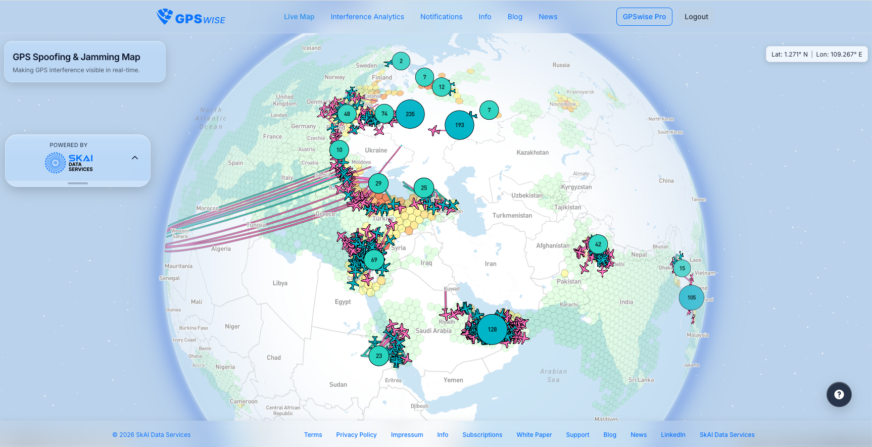
Expanded ADS-B Coverage with Wingbits Integration
The biggest change in this release is the integration of an additional ADS-B data provider: Wingbits.
Wingbits brings strong global coverage to the GPSwise data pipeline, significantly improving our ability to monitor GPS interference across a wider area. With more aircraft data available to the platform, users benefit from a more complete view of interference activity. Coverage has been greatly improved in India, Pakistan, Indonesia, around the Red Sea, in Mexico, and across Latin America.
"GPS spoofing and jamming are among the most critical and fast-evolving safety challenges in aviation today, and we’re excited to contribute our data to SkAI’s platform. Wingbits’ network captures high-resolution GPS interference signals globally and especially in regions that have historically lacked coverage. By feeding this data into SkAI, we enhance detection fidelity, expand geographic coverage, and strengthen signal-level visibility, delivering a more complete and actionable picture of what’s happening in the skies. This partnership highlights how community-powered infrastructure can materially improve real-world aviation safety." Alex Lungu, CEO Wingbits
And Improved Reliability
This does not replace OpenSky Network. GPSwise now uses both Wingbits and OpenSky Network, giving us the advantages of broader coverage, increased robustness, and built-in redundancy. By combining two ADS-B networks, SkAI is making GPSwise more reliable, especially in situations where continuous visibility matters most.
Faster Jamming Detection
This release also improves how quickly GPSwise detects interference events.
GPS spoofing has always been monitored in real time, with detection possible within seconds, but jamming data was previously updated only once per hour. Jamming data is now updated every 10 minutes, enabling faster detection and giving users a more timely picture of what is happening in the airspace.
Higher-Resolution Interference Mapping
We have also improved the spatial resolution of our jamming analysis by introducing a smaller H3 grid resolution.
This allows interference to be mapped with greater precision, helping users identify affected areas in more detail.
New Flight Interaction
Another important usability improvement: users can now click on a flight directly in GPSwise.
This makes it easier to explore individual aircraft affected by GPS interference and adds a more intuitive layer of interaction to the platform. Whether investigating a specific event or monitoring wider patterns, this feature helps connect the map view to the underlying flight activity more directly.
Built for Better Monitoring
Together, these updates mark a significant step forward for GPSwise. With stronger ADS-B coverage through Wingbits, continued support for OpenSky Network, faster update cycles, higher-resolution mapping, and improved flight-level interaction, SkAI is making GPSwise more powerful for professionals who need timely, dependable GPS interference intelligence.
About Wingbits
![]()
Wingbits is a Swedish global flight-tracking network that collects real-time aircraft data through community-operated receivers. Unlike traditional flight-tracking networks, Wingbits uses an incentive-based model to fairly reward its contributors. Thanks to purpose-built hardware, Wingbits delivers fully encrypted real-time and historical data with provable integrity.
Key facts:
- Founded in 2023 in Stockholm by Alex Lungu and Robin Wingårdh
- Network of 5,500+ stations across 120+ countries
- Tracking up to 200,000 flights daily
- Backed by leading investors including Tribe Capital, Borderless, Bullish, Spartan Group, SNZ, and HeartCore, with initial seed funding from Antler
- Key partners include Korean Air R&D, Meerir, Spire Global, ANRA Technologies, SkAI, and GEODNET